
Hiking Route - Le sommet de Razis - 6


Contact
Front de neige D1
A gauche du télépulsé
05600
Risoul
- Spoken language(s) :
- French
Presentation
Reach the summit ! Reachable by lift, for a descent achievable in 2 hours, or without, for a committed route.
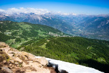
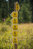
Departure at D1! 1h45 walk on forest road, follow the Mélèzet road, which connects Risoul to Vars, then when you see the directional sign n*6, turn right and start the ascent. This route is meant to be sporty, you will reach an altitude of 2571 m, the highest point in Risoul. A varied and technical course alternating between steep slope & forest track. Once at the top, a superb panorama awaits you. A bird's eye view of Risoul, Vars & the entire Durance valley.
The descent is carried out by the same route, or, if you wish, by chairlift with the R5-La Plate de la Nonne!
The descent is carried out by the same route, or, if you wish, by chairlift with the R5-La Plate de la Nonne!
General
- Route :
- Route 2100
- Distance (km) 13
- Route Aller / Retour
- Elevation (m) 721
- Daily duration (minutes) 330
- Route 721
- Route 2270
- Levels of sporting experience :


Destination
Itinéraire de randonnée - Le sommet de Razis - 6
Front de neige D1
A gauche du télépulsé
05600
Risoul
GPS coordinates
Latitude : 44.620696
Longitude : 6.633074