
Hiking route - La grand panorama - 8


Contact
Espace rencontre D2
a droite de l'espace rencontre
05600
Risoul
- Spoken language(s) :
- French
Presentation
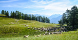
Breathtaking views of the surrounding valleys!
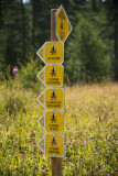
Departure at D1! The route begins on the road to Vars, pass the Razis hut, continue on the forest road to the directional sign which will then direct you to follow a path which will want to be ascending to the Pointe de Razis (2575m)
You will descend on the opposite side, to go up to the col de valbelle, at the top of the latter, the ridge path will allow you to access the man of Pierre, famous point of view which offers you a panorama on the valley. embrunais and the lake of Serre-Ponçon.
The descent can then begin, the path will join the Martinat forest road, turn left and follow the road for about forty minutes to reach the snow front.
General
- Route :
- Distance (km) 12
- Route BOUCLE
- Elevation (m) 831
- Daily duration (minutes) 300
- Route 831
- Route 2575
- Levels of sporting experience :

- For experts / practiced
FICHE_INFO_SIMPLE_LIBELLE_DESTINATION
Itinéraire de randonnée - Le grand Panorama - 8
Espace rencontre D2
a droite de l'espace rencontre
05600
Risoul
GPS coordinates
Latitude : 44.620696
Longitude : 6.633074